
About the Mountain-West Region of North Carolina
go.ncsu.edu/readext?816519
en Español / em Português
El inglés es el idioma de control de esta página. En la medida en que haya algún conflicto entre la traducción al inglés y la traducción, el inglés prevalece.
Al hacer clic en el enlace de traducción se activa un servicio de traducción gratuito para convertir la página al español. Al igual que con cualquier traducción por Internet, la conversión no es sensible al contexto y puede que no traduzca el texto en su significado original. NC State Extension no garantiza la exactitud del texto traducido. Por favor, tenga en cuenta que algunas aplicaciones y/o servicios pueden no funcionar como se espera cuando se traducen.
Português
Inglês é o idioma de controle desta página. Na medida que haja algum conflito entre o texto original em Inglês e a tradução, o Inglês prevalece.
Ao clicar no link de tradução, um serviço gratuito de tradução será ativado para converter a página para o Português. Como em qualquer tradução pela internet, a conversão não é sensivel ao contexto e pode não ocorrer a tradução para o significado orginal. O serviço de Extensão da Carolina do Norte (NC State Extension) não garante a exatidão do texto traduzido. Por favor, observe que algumas funções ou serviços podem não funcionar como esperado após a tradução.
English
English is the controlling language of this page. To the extent there is any conflict between the English text and the translation, English controls.
Clicking on the translation link activates a free translation service to convert the page to Spanish. As with any Internet translation, the conversion is not context-sensitive and may not translate the text to its original meaning. NC State Extension does not guarantee the accuracy of the translated text. Please note that some applications and/or services may not function as expected when translated.
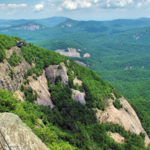
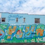
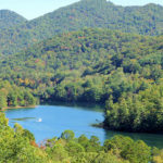
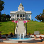
Collapse ▲Jackson, Macon, Swain, and Graham counties are a contiguous region at the confluence of the Balsam, Nantahala, and Great Smoky ranges in the Blue Ridge Mountains of Southwestern North Carolina. The Qualla Boundary, home of the Eastern Band of Cherokee Indians, is situated as portions of both Northern Jackson and Swain Counties. The four-county region is comprised of numerous small municipalities and villages that have long been appealing to tourists, outdoor enthusiasts, and second home buyers. The Town of Highlands and the Village of Cashiers are similar, high-elevation destinations on the southern escarpment of the region. The four county seats include the population centers of Sylva (Jackson), Franklin (Macon), Bryson City (Swain), and Robbinsville (Graham), with each offering unique appeal to the traveling public.
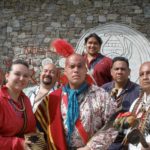
Within the Qualla Boundary is the town of Cherokee, the cultural and governmental center for the Eastern Band of Cherokee Indians, which is long noted as a vacation destination for people from the Southeastern United States and beyond. Each county within the CREATE BRIDGES Mountain West NC region has additional retail and tourism destinations such as Dillsboro and the Nantahala River Gorge, both known for whitewater rafting and exceptional dining, shopping and lodging experiences. Known as the gateway to the Great Smoky Mountains National Park and the Blue Ridge Parkway, this region finds itself in need of a collaborative and adaptive planning initiative to address challenges with workforce and retention, service training and engagement, and business scalability.